April 5, 2026
The 5 Most Difficult Grande Randonnée (GR) Trails in France
Walking Grande Randonnee trails in France can feel as much like an alpine adventure as a long-distance hike. Some routes require sustained endurance, excellent technical confidence on rocky terrain, and the ability to adapt to rapidly changing weather. The text below presents five of the country’s most demanding GR trails, combining numerical data, descriptions of key points of interest, and practical advice to prepare each crossing with confidence.
GR 20 (Corsica) — alpine intensity in trail format
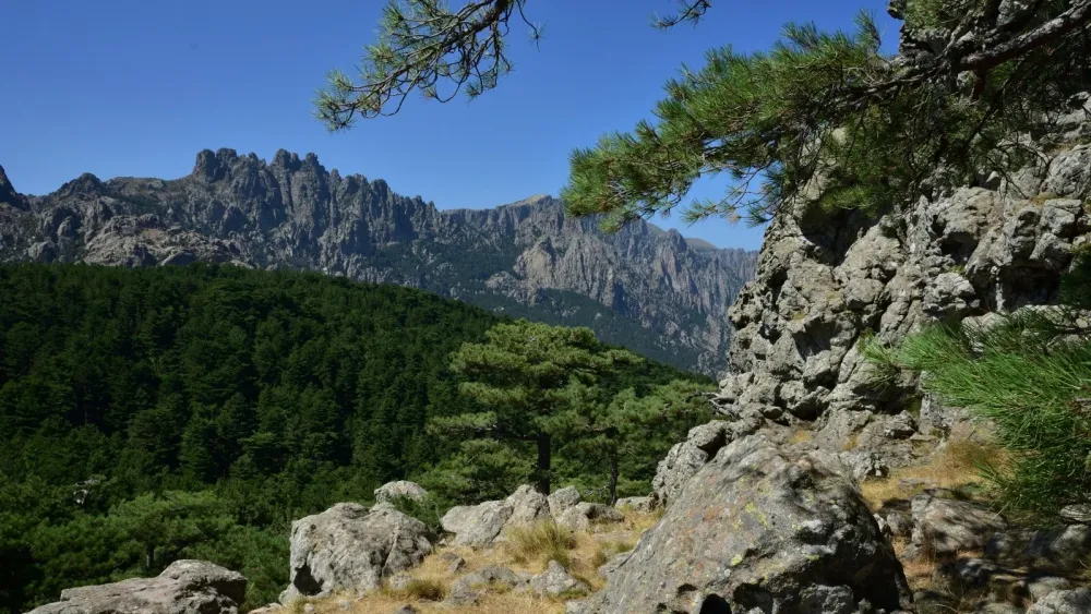
On the GR 20, the mountain imposes itself without compromise: this is roughly 180 km of ridgelines and needle-like rock formations, with cumulative positive elevation generally estimated between 12,000 and 14,000 m depending on the chosen route and direction of travel. Technical sections alternate granite slabs, fragile cairns, and late snow patches; the route skirts summits such as Monte Cinto and occasionally reaches around 2,600 m.
This broken terrain turns sections of around twenty kilometers into very demanding days: daily effort can reach 1,200 to 2,000 m of climbing and just as much descending. In high season, you need to book refuges and lodgings in advance. To prepare for the GR 20, prioritize trail sessions on technical terrain, work on ankle strengthening, and simulate 6–10 hour days with a 30–40 kg pack if your plan is to bivouac. Water is often available, but always check sources and purify when necessary.
Information and practical advice: GR 20 in Wikipedia
In summary:
• Distance: around 170 to 180 km depending on variants.
• Cumulative elevation gain: ~12,000 to 14,000 m of total ascent, depending on the route.
• Typical duration: 8 to 14 days depending on pace and bivouac/refuge choices.
• Difficulty: very difficult. Rocky sections, exposed passages, and technical descents.
• Approximate maximum altitude: 2,600 m.
Main points of interest:
• Cirque de la Solitude :
The Cirque de la Solitude is historically considered the most technical passage on the GR20, even though the official route was modified after rockfalls. It remains a benchmark in terms of difficulty and commitment.
This sector is defined by:
• a very steep descent into a closed mineral cirque
• passages equipped with chains, ladders, or cables
• strong exposure with little room for error
The terrain is unstable, made up of blocks and rock slabs, often slippery in wet conditions. Progress requires attention on every foot placement, especially downhill where fall risk is highest.
Even on current variants, the spirit remains the same. This is alpine terrain, where accumulated fatigue makes every section more demanding. This passage perfectly illustrates the technical dimension of the GR20, far beyond simple hiking.
• Bavella needles and pass :
The Bavella needles offer a spectacular contrast with the rest of the GR20. Here, the landscape becomes more sculpted, almost Dolomite-like, with sharp peaks dominating laricio pine forests.
This sector is characterized by:
• highly aesthetic jagged rocky ridges
• technical passages that are often more playful than dangerous
• alternation between forest, rock, and open views
The Bavella pass is a major access point and an important logistical marker. It is also an area where weather can change quickly, with frequent winds.
The play of light on red rocks and cut relief makes it one of the most photogenic sections of the GR20. The atmosphere is more varied, less austere than in the north, but remains physically demanding.
• Lac d’Oriente :
The high-altitude lakes on the GR20 create breaks in an environment that is often mineral and exposed. They play a key role in effort management by offering mental and physical recovery points on a highly committing route. Lac d’Oriente is one of the most emblematic.
You will appreciate:
• a calm water surface contrasting with the harsh terrain
• opportunities for a break, even swimming in summer
• a possible water resupply point (with recommended filtration)
Lac d’Oriente sits in an open setting surrounded by rounded relief, creating a calmer atmosphere.
GR 10 (Pyrenees range) — the crossing of a continuous ridge
The GR 10 crosses the Pyrenees from the Atlantic to the Mediterranean over around 860–870 km, a route that often requires 45 to 60 days depending on pace. Cumulative positive elevation across the whole route is massive: frequent estimates mention 30,000 to 50,000 m depending on route variations and chosen options.
Length and altitude make the GR 10 demanding not only physically but also logistically: variable water reserves, isolated sections, and rapidly changing mountain weather. To commit to it, plan realistic stages (between 15 and 25 km per day depending on profile), carry enough calories for cold and wet days, and master map reading and orientation without relying exclusively on GPS. Good preparation through multi-day backpacking experience (several consecutive multi-day hikes) reduces injury and exhaustion risk.
More information: GR10 in wikipedia
In summary:
• Distance: around 860-870 km depending on variants.
• Cumulative elevation gain: 30,000 to 50,000 m depending on variants
• Duration: 45 to 60 days for a full route, difficult sections can be done in 7 to 15 days.
• Difficulty: difficult. Trails sometimes steep with frequent elevation changes.
• Maximum altitude: often above 2,500 m on some passes.
Main points of interest:
• Emblematic peaks: Neouvielle, Vignemale
The GR10 does not systematically go to the summit of the highest peaks, but it runs in immediate proximity to some of the most emblematic Pyrenean massifs, notably Neouvielle and Vignemale.
The Neouvielle massif stands out for an exceptional concentration of high-altitude lakes and softer granite relief. The atmosphere is more open, with bright landscapes and a strong presence of mountain pines, quite rare at this altitude. Variants allow you to approach remarkable sites such as Lakes Aubert and Aumar.
Vignemale, more massive and more mineral, creates a very different atmosphere. The highest summit in the French Pyrenees, it is associated with a glacial environment, notably around the Ossoue glacier.
• Pastoral valleys :
The GR10 crosses many valleys shaped by pastoralism, still very active today. These zones are an essential part of the Pyrenees’ identity.
You can observe:
• summer mountain pastures occupied by flocks of sheep, cattle, or horses
• shepherd huts still in use
• open landscapes maintained by grazing
Progress is generally less technical here, but still demanding because of distances and cumulative elevation gain. These valleys also offer occasional resupply points, sometimes as refuges or sheepfolds selling local products.
Contact with pastoral areas requires a few precautions. The presence of livestock guard dogs means you should adapt your behavior, notably by calmly bypassing herds.
• Basque and Bearn villages :
The GR10 is also a cultural crossing. It links villages with very marked identities, especially in Basque and Bearn sections.
In the Basque Country, villages are recognizable by their white houses with red or green timber framing, often grouped around a church or pelota fronton. The atmosphere remains strongly rooted in local traditions, with language and culture still very present.
Further east, in Bearn, architecture changes. Houses become more massive, built in stone, with slate roofs. Villages are often more spread out, integrated into broad valleys
• Wildlife : isards, marmots, vultures depending on sector.
GR 5 / Grande Traversee des Alpes (Haute Route) — alternating altitude and sustained effort
The alpine section of the GR 5, often called Haute Route or Grande Traversee des Alpes, links Lake Geneva to the Mediterranean over around 600–700 km depending on variants, with cumulative positive elevation generally estimated between 30,000 and 40,000 m. Crossings of glacial passes, high plateaus, and steep descents toward valleys characterize this route.
Daily effort on the Haute Route can exceed 1,500 m of ascent on long and exposed stages; the succession of passes requires good recovery and adapted nutrition. Recommended preparation: hill training, long hikes with recurrent elevation gain, familiarity with crampons and ice axe if the season brings snow patches, and checking access alternatives in case of weather failure.
Practical information and variants: GR5 in wikipedia
In summary:
• Distance: between 600 and 700 km
• Cumulative elevation gain: between 30,000 and 40,000 m
• Duration: high-mountain sections 10 to 30 days depending on chosen segment.
• Difficulty: variable, but some alpine stages are very demanding, technical, and exposed.
• Maximum altitude: several passes >2,500 m, depending on variant.
Main points of interest:
• Massifs crossed: Beaufortain, Vanoise, Ecrins, Mercantour
The Grande Traversee des Alpes is above all a crossing of major alpine groups, each with a very marked identity.
The Beaufortain often opens the route with relatively gentle landscapes. Ridges are broad, slopes covered with alpine pastures, and panoramas are open, notably toward Mont Blanc. The terrain remains demanding in terms of elevation gain, but technically accessible.
The Vanoise marks a transition toward a more structured mountain environment. France’s first national park, it hosts abundant wildlife, notably ibex. Routes cross glacial zones, high passes, and hanging valleys. The atmosphere becomes more mineral while remaining relatively welcoming.
The Ecrins massif is a high point in terms of commitment. Here, high mountain is omnipresent. Relief is abrupt, glaciers numerous, and some stages long and isolated. Conditions can change quickly, and the route requires good effort and orientation management.
The Mercantour, further south, introduces a different atmosphere. Relief gradually opens up, light becomes more Mediterranean, and landscapes alternate between mineral and drier vegetation. High-altitude lakes are numerous, and wildlife (notably chamois and sometimes wolves) is well established.
• Alpine hamlet villages
Alpine hamlet villages are essential breathing points on the GTA. Unlike valley villages, they are located at altitude and directly linked to pastoral activity.
These hamlets are characterized by:
• wooden or stone chalets, often old
• seasonal occupation linked to summer pastures
• very strong integration into the landscape
Historically, they supported the movement of herds to higher ground in summer. Today, some are still active, while others have been partially restored to host hikers.
• Refuge du Promontoire :
Refuge du Promontoire is one of the most emblematic refuges in the French Alps, especially in the Ecrins massif. It stands out for its spectacular location, literally clinging to the mountain above La Berarde.
Located at over 3,000 meters altitude, it overlooks a very mineral high-mountain environment, with direct views of major summits such as La Meije.
This refuge is characterized by:
• demanding access, with rocky and sometimes exposed passages
• a balcony-like setting offering an exceptional panorama
• visitor traffic often linked to mountaineering routes
The approach requires good physical condition and sure-footed movement, especially on the final sections. This is not an “easy” refuge, and it often marks a transition toward a more technical environment.
Tour du Mont Blanc (TMB) — technique and altitude on a short route
The Tour du Mont Blanc covers around 170 to 175 km and totals around 9,500 to 11,000 m of positive elevation depending on the variant. Although shorter than major crossings, the TMB remains one of the most demanding routes due to its intense pace, airy passages, and the relative altitude of crossed passes (often between 2,300 and 2,600 m).
The TMB requires strong walking days if the goal is to complete it in 7–10 days; this effort concentrates fatigue and exposes hikers to altitude effects. To prepare, build endurance over several consecutive days, multiply elevation outings, refine nutrition management during effort, and take care with foot preparation (adapted footwear, blister prevention).
Resources and route info: TMB in wikipedia and detailed TMB info
In summary:
• Distance: 170 to 175 km
• Cumulative elevation gain: 9,500 to 11,000 m of positive elevation depending on variant
• Duration: between 7 and 11 days, depending on pace and chosen variants
• Difficulty: Moderate to sustained difficulty (physical), low to moderate (technical)
• Maximum altitude: around 2,665 meters, at Col des Fours (variant)
Main points of interest:
• Val Veny and views of Mont Blanc (Italy) :
Val Veny probably offers one of the best overall viewpoints of the Mont Blanc massif. Unlike the French side, often more enclosed, this Italian valley opens the landscape widely.
The view looks directly onto:
• the Miage glacier, impressive for its size and dark moraine
• the great faces of the massif, with very clear terrain reading
• open alpine meadows contrasting with high mountain
Progress is smoother here, allowing you to truly enjoy the panorama.
• Grand Col Ferret (on the border between Italy and Switzerland) :
Grand Col Ferret marks a very clear change of atmosphere on the TMB. It is the crossing point between Italy and Switzerland, and this transition is immediately noticeable.
From the pass:
• the view opens onto the Swiss valley, gentler and greener
• the relief becomes less abrupt
• the sense of space is much stronger
It is an emblematic passage because it combines:
• physical effort (steady but sustained climb)
• immediate visual reward
• a real sense of geographic crossing
• Col de la Seigne (on the border between France and Italy) :
Col de la Seigne is one of the most striking passages on the French side of the TMB. It offers a direct and spectacular view of the Mont Blanc massif.
This pass stands out for:
• a progressive but demanding climb
• arrival on a very open ridge
• a frontal view of glaciers and major summits
The contrast is particularly strong between:
• grassy approach slopes
• the glacial world visible in the distance
This is a point where the alpine dimension of the TMB becomes fully visible, while still not requiring technical skills. The experience remains accessible, but visually very impressive.
GR 52 / Tour du Mercantour — high mountain, isolation, and abrupt terrain
The GR 52 crossing the Mercantour and surrounding areas covers routes on the order of 200 to 300 km depending on loops and variants, with cumulative positive elevation that can exceed 12,000 to 15,000 m on long itineraries. The national park offers passes often above 2,500 m, enclosed valleys, and alpine pasture zones historically used by shepherds.
Difficulties come from the technical nature of certain sections (scree fields, exposed passages), weather variability, and distance from rescue on some portions. Useful preparation: training on broken terrain, familiarity with IGN topo guide reading, rigorous planning of stages and water points, and pre-booking refuges whenever possible.
Additional information: Parc du Mercantour in Wikipedia
In summary:
• Distance: 200 to 300 km depending on chosen loop.
• Cumulative elevation gain: 12,000 to 15,000 m on long itineraries. Several sustained mountain stages.
• Duration: 7 to 20 days.
• Difficulty: difficult to very difficult on some sections, especially at altitude.
• Maximum altitude: passes often >2,500 m.
Main points of interest:
• Mercantour National Park :
Mercantour National Park is one of the most distinctive sectors in the French Alps, notably because of its geographic position between alpine and Mediterranean influences.
This positioning is directly visible on the ground. In a few hours of walking, landscapes shift strongly, alternating between mineral high-altitude zones, wooded valleys, and drier south-facing slopes.
One of the most striking elements remains the density of high-altitude lakes, often of glacial origin. These numerous, scattered lakes structure stages and provide strong visual landmarks. They also play a practical role, notably for water access, although filtration remains recommended.
The park is also known for its particularly rich wildlife. Encounters with chamois are frequent, ibex sightings are possible in some zones, and wolf presence, while discreet, still influences pastoral practices. This richness is explained by territorial protection and relatively low human pressure in some areas.
Another major point of interest is the Vallee des Merveilles, famous for its thousands of Bronze Age rock engravings. These engravings, spread across rock slabs, testify to ancient human occupation and give hiking a unique historical dimension.
Finally, Mercantour stands out for its light and climate. Mediterranean influence creates stronger contrasts. Summers can be hot on lower sections, while storms are frequent at altitude. This variability requires good schedule and exposure management.
• Haut-Verdon valleys :
The Haut-Verdon valleys offer a gradual transition between alpine high mountain and the more open landscapes of the Southern Alps. They are located upstream from the famous Verdon gorges, in a much quieter and less frequented environment.
Relief is generally more accessible there than in central alpine massifs, with:
• broad and relatively open valleys
• less abrupt slopes
• alternation between meadows, forests, and alpine pasture zones
The presence of the young Verdon River, still modest at this stage, structures the landscape. The river winds between reliefs, bringing freshness and regular water points. The Verdon sources are also a specific point of interest, often included in hiking routes.
Villages such as Colmars-les-Alpes strongly mark the territory. Their mountain architecture, sometimes fortified, recalls the historical strategic importance of these valleys, notably near the Italian border.
General preparation advice to approach these GRs with confidence
Preparation is built on three components: physical, technical, and logistical. Physically, develop an endurance base through weekly long outings (progressing toward 5–8 hour hikes), strengthen stabilizing muscles, and accustom joints to repeated elevation changes. Technically, repeat technical terrain (slabs, scree, exposed passages) and train descending, often more traumatic for knees. Logistically, establish a resupply and overnight plan: booking refuges in high season, checking snowmelt periods (especially for GR 20 and high-mountain sections), and preparing modular gear according to weather.
For equipment, prioritize mountain footwear ensuring grip and protection, a pack suited to duration (30–60 L depending on autonomy), technical layered clothing, and water purification methods. On alpine routes, lightweight crampons, an ice axe, and basic winter safety knowledge may be required outside summer. Always carry an emergency kit (compass/paper topo, survival blanket, first-aid kit, phone with external battery) and inform a contact of itinerary and schedule.
The GRs presented here combine distance, elevation gain, technical difficulty, and isolation: the challenge is as much physical as mental and logistical. Progressive preparation, detailed stage knowledge, and humble management of weather and fatigue allow you to approach these routes safely and with pleasure.
FAQ
Q : What is the best season to attempt the GR 20 ?
R : The summer period (mid-June to late September) concentrates the best conditions, with peak traffic in July-August. Late June-early July limits late snow patches but can also mean fewer open refuges; check passage conditions early in the season.
Q : How long does it take to cross the GR 10 ?
R : Generally, plan for 45 to 60 days for the full route depending on fitness, pace, and chosen variants. Sections can be completed in shorter segments depending on availability.
Q : Do you need mountaineering skills for the Haute Route (GR 5) ?
R : Classic summer variants can be done as alpine hiking, but some sections, depending on snow conditions and route choices, require high-mountain skills and gear (knots, crampons, ice axe). Check pass conditions before departure.
Q : Is it possible to bivouac freely on these GR trails ?
R : Rules vary by territory: bivouac is generally tolerated but regulated in protected zones (national parks) and sometimes forbidden above certain hours. Ask local tourist offices and respect environmental rules.
More informations: Wild Camping in France: where and how to sleep outdoors
Q : What are warning signs for abandoning a stage ?
R : Signs of hypothermia, persistent sharp pain, extreme fatigue preventing progress, or a sudden weather change are all valid reasons to shorten a stage, reach a refuge, or contact rescue services. Caution always comes before completing a route.